


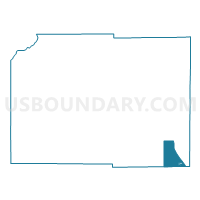
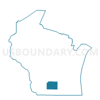
ALBION - T 1 Voting District, Dane County, Wisconsin
About
Outline

Summary
| Unique Area Identifier | 693068 |
| Name | ALBION - T 1 Voting District |
| County | Dane County |
| State | Wisconsin |
| Area (square miles) | 19.14 |
| Land Area (square miles) | 19.05 |
| Water Area (square miles) | 0.09 |
| % of Land Area | 99.52 |
| % of Water Area | 0.48 |
| Latitude of the Internal Point | 42.88373530 |
| Longtitude of the Internal Point | -89.08824770 |
Maps

Graphs
Select a template below for downloading or customizing gragh for ALBION - T 1 Voting District, Dane County, Wisconsin


Neighbors
Neighoring Voting District (by Name) Neighboring Voting District on the Map
- ALBION - T 2 Voting District, Dane County, WI
- CHRISTIANA - T 2 Voting District, Dane County, WI
- DUNKIRK - T 2 Voting District, Dane County, WI
- Edgerton - C 1 Voting District, Rock County, WI
- Edgerton - C 2 Voting District, Rock County, WI
- Edgerton - C 3 Voting District, Rock County, WI
- Edgerton - C 5 Voting District, Rock County, WI
- Edgerton - C 7 Voting District, Dane County, WI
- FULTON - T 2 Voting District, Rock County, WI
- FULTON - T 3 Voting District, Rock County, WI
- FULTON - T 4 Voting District, Rock County, WI
- PLEASANT SPRINGS - T 3 Voting District, Dane County, WI
- PORTER - T 1 Voting District, Rock County, WI
Top 10 Neighboring County Subdivision (by Population) Neighboring County Subdivision on the Map
- Edgerton city, Rock County, WI (5,364)
- Fulton town, Rock County, WI (3,252)
- Pleasant Springs town, Dane County, WI (3,154)
- Albion town, Dane County, WI (1,951)
- Dunkirk town, Dane County, WI (1,945)
- Christiana town, Dane County, WI (1,235)
- Porter town, Rock County, WI (945)
- Edgerton city, Dane County, WI (97)
Top 10 Neighboring Place (by Population) Neighboring Place on the Map
Top 10 Neighboring Unified School District (by Population) Neighboring Unified School District on the Map
- Stoughton Area School District, WI (20,696)
- Edgerton School District, WI (11,389)
- Cambridge School District, WI (5,783)
Top 10 Neighboring State Legislative District Lower Chamber (by Population) Neighboring State Legislative District Lower Chamber on the Map
- Assembly District 46, WI (65,837)
- Assembly District 37, WI (58,965)
- Assembly District 43, WI (57,584)
Top 10 Neighboring State Legislative District Upper Chamber (by Population) Neighboring State Legislative District Upper Chamber on the Map
- State Senate District 16, WI (188,936)
- State Senate District 13, WI (175,277)
- State Senate District 15, WI (170,251)
Top 10 Neighboring 111th Congressional District (by Population) Neighboring 111th Congressional District on the Map
Top 10 Neighboring Census Tract (by Population) Neighboring Census Tract on the Map
- Census Tract 119, Dane County, WI (6,701)
- Census Tract 30.01, Rock County, WI (5,037)
- Census Tract 30.02, Rock County, WI (4,996)
- Census Tract 120.02, Dane County, WI (4,804)
- Census Tract 121, Dane County, WI (2,637)